
Overview of Iwaki City
Location & Topography
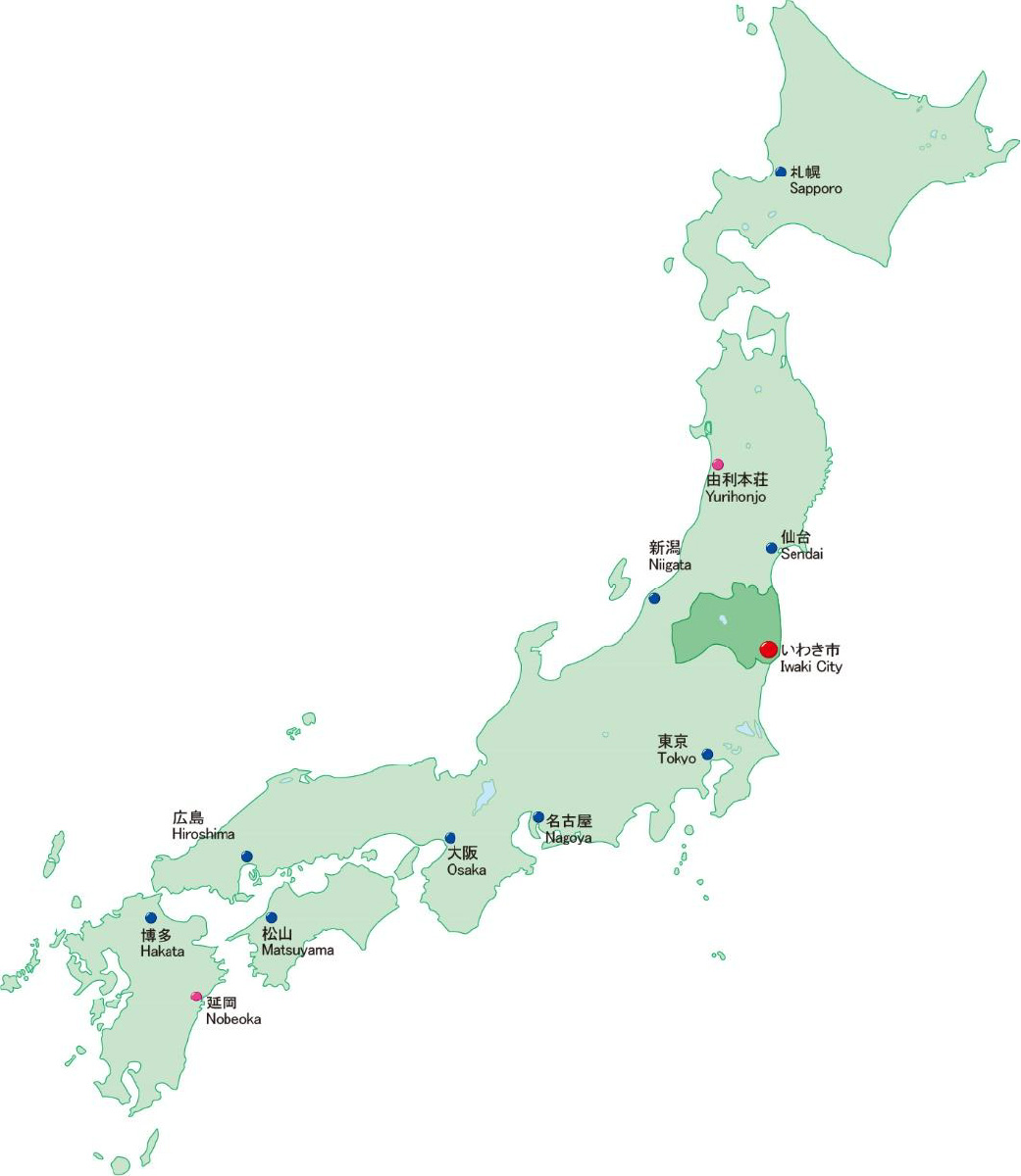
Iwaki City is located in southeast Fukushima. To its south is Ibaraki Prefecture, and to its east the Pacific Ocean. The city enjoys a comparatively moderate climate.
With an area of 1,232.51 km2, the city is around twice the size of the 23 wards of Tokyo.
The terrain gently slopes downward from the Abukuma Mountains in the west toward the east, where the landscape transitions into plains and rolling hills, particularly on the eastern side around the river mouths of the Natsui and Same Rivers.
Along the Pacific coast, the 60-kilometer stretch of shoreline alternates from white sandy beaches, to pine forests, to rugged cliffs, creating the picturesque scenery known as the Iwaki Nanahama (Iwaki’s Seven Shores).
City Information (as of May 1st, 2024)
(1)Population: 318,946
(2)Households: 141,634
(3)Area: 1,232.51 ㎢
(4)Coordinates: 37˚03'02" N 140˚53'16" E
(5) Transportation
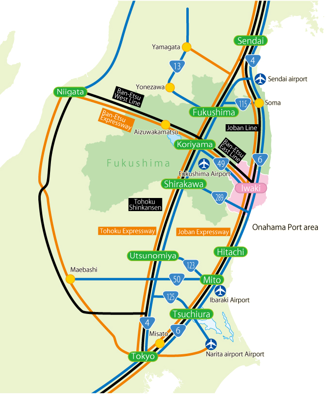
①Highways
○Joban Expressway Misato IC- Iwaki-Chuo IC approx. 2 hours
○Sendai-Tobu Road・Joban Expressway Sendai-Higashi IC- Iwaki-Chuo IC approx. 2 hours
○Joban Expressway
Koriyama-Higashi IC1.C- Iwaki-Chuo IC approx. 50 min
Niigata-Chuo IC- Iwaki-Chuo IC approx. 3 hours
② JR Joban Line
Shinagawa - Tokyo - Ueno - Iwaki Limited Express Hitachi approx. 2 hours
③ Narita Airport
Ban-Etsu Expressway-Ken-O Expressway-Shin-Kuko Expressway approx. 2 hours
④ Sendai Airport
Ban-Etsu Expressway-Sendai-Tobu Road approx. 2 hours
⑤ Fukushima Airport
Ban-Etsu Expressway-Ban-Etsu Expressway Abukuma Kogen Road approx. 70 min
Iwaki City Industries
-
1.History
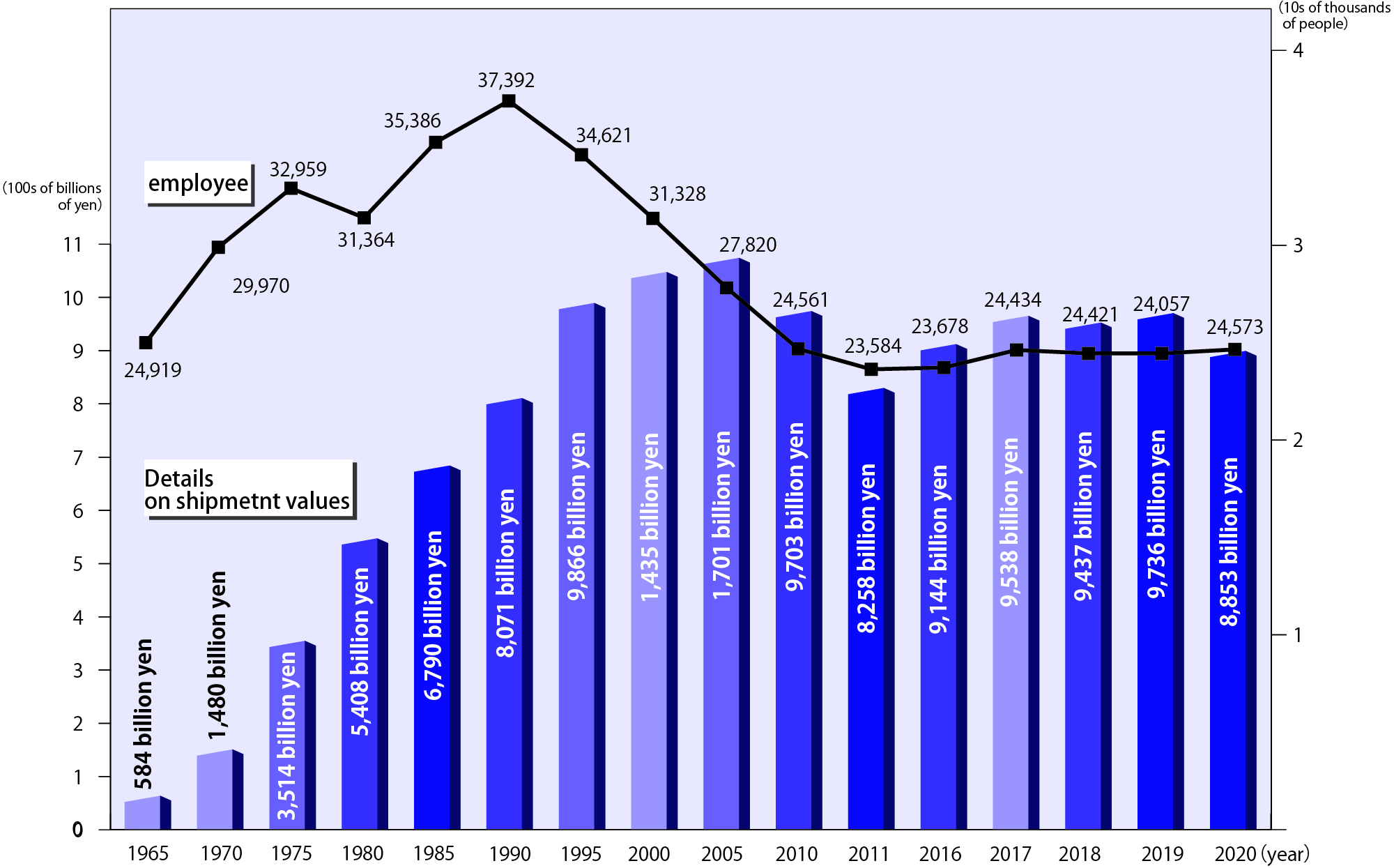
Since the Meiji period, industry in Iwaki grew and developed largely around the coal industry. But after the energy revolution that came about in the late 1950s, this industrial structure has been forced to undergo change.
After designation in the Act on Temporary Measures for Coal Mining Regions (1962) and the Act on Promotion of New Industrial City Construction (1964), Fukushima Prefecture and the Organization for Small & Medium Enterprises and Regional Innovation (formerly the Regional Development Corporation) worked to establish and develop a growing number of industrial parks. This led the area to grow into one of Eastern Japan’s leading industrial cities—one which competes with Sendai City for the total amount of manufactured and shipped products in the Tohoku region. -
2.Today
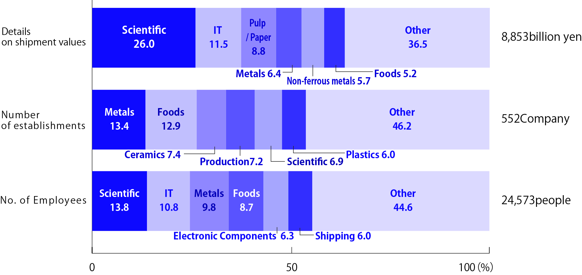
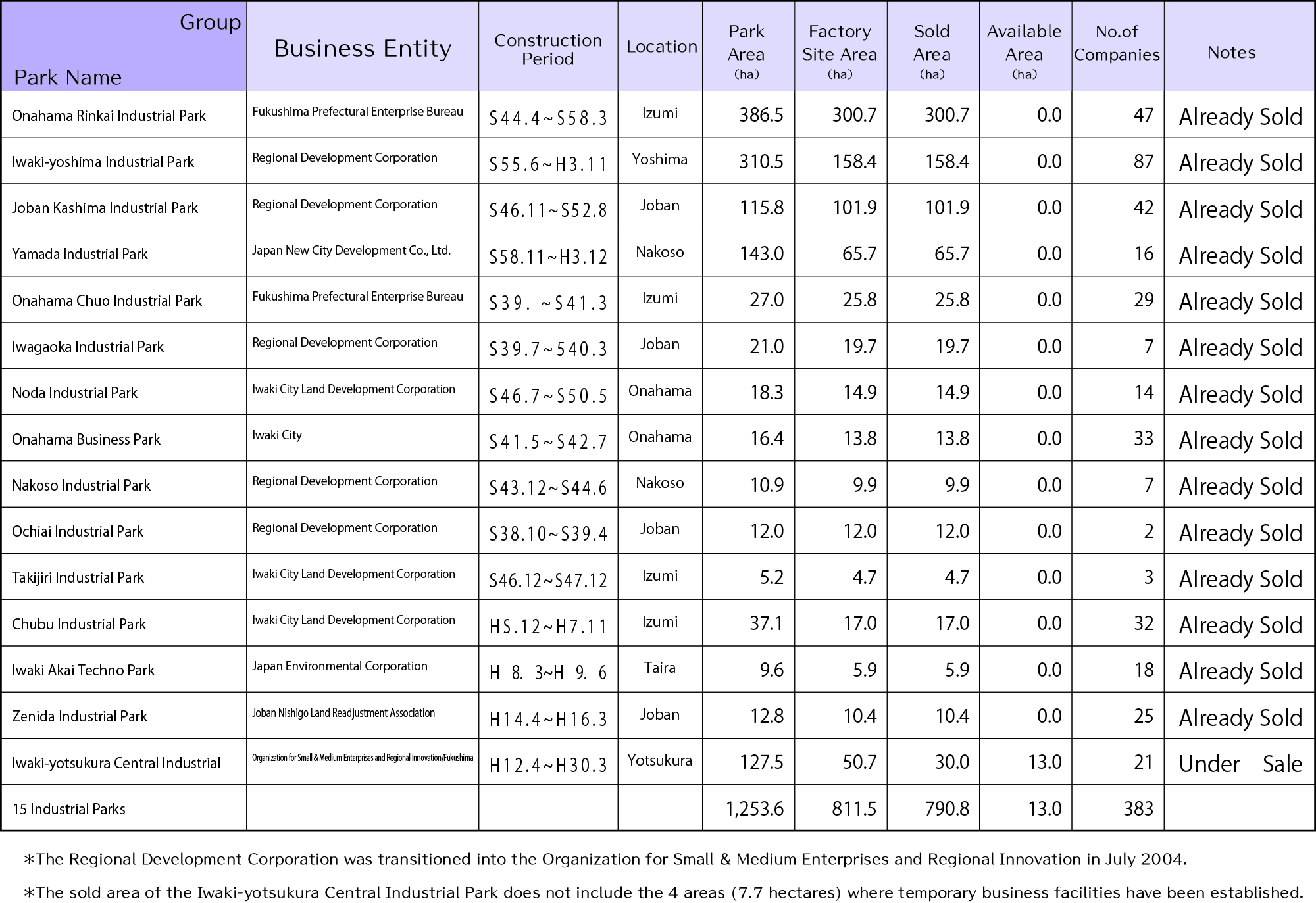
Today our city is home to 15 industrial parks, including the Onahama Rinkai Industrial Park along the coast and Iwaki-yotsukura Central Industrial Park in an inland area. These regions ship approximately 885.3 billion yen worth of products, accounting for nearly 18.6% of Fukushima Prefecture’s total of 4,767 billion yen.
Chemical manufacturing accounts for 26.0% of this total, followed by information and communication equipment manufacturing at 11.5% and pulp, paper, and paper products manufacturing at 8.8%. Together, these top three industries continue to represent almost half of the total shipment value of manufactured goods. Other key sectors include metal products, non-ferrous metals, and food manufacturing.
-
■Workers, Shipment Value, and More
-
■Details on shipment values, number of establishments, and number of employees by industry (2021 Economic Census)
-
■List of Industrial Parks (as of March 1st, 2023)
Educational institutions in Iwaki City
Copyright ©︎2024 IWAKI MANUFACTURING COMPANY ARCHIVE All Rights Reserved.
